
Commercial navigation has been built on a quiet promise for decades: positioning is a stable piece of data. In the Persian Gulf and Oman Gulf, that promise is breaking at an industrial scale. Since February 28, 2026, with the military escalation in Iran and the American offensive known as Operation Epic Fury, incidents of GNSS (GPS) interference and manipulation of AIS (Automatic Identification System) have multiplied, affecting hundreds and then thousands of vessels within days. On March 7, over 1,650 vessels reported interference, a 55% increase from the previous week. On the first day after the operation commenced, nearly 1,100 ships were impacted, with at least 30 clusters of interference detected in Saudi Arabia, Kuwait, the United Arab Emirates, Qatar, Oman, and Iran, both on land and offshore.
The pattern has shifted from a sporadic anomaly to a layer of permanent noise. Lloyd’s List Intelligence recorded 655 affected cargo vessels since February 28, accumulating 1,735 events typically lasting three to four hours. In the initial days, the daily incidents doubled from 350 at the onset of the conflict to 672 by March 2. The concentrations are clear: around 600 events off the UAE, over 80 off Iran, about 50 off Oman, and nearly 10 off Qatar. In other words: the world’s most sensitive energy corridor is operating with a disrupted nervous system.
What for many executives still sounds like a "navigation problem" is, in practice, a market problem. Because when GPS fails, the product being sold is no longer just maritime transportation. It’s a promise of arrival, credible traceability for compliance, a reasonable insurance premium, and an acceptable probability of not becoming the headline due to a collision or grounding.
Electronic Warfare Has Already Changed the Definition of Operational Security
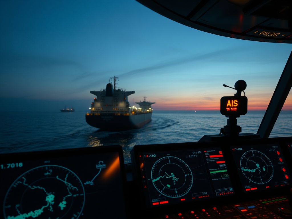
Interference does not just erase the position. It replaces it with an operational lie that has physical consequences. Windward described the evolution of patterns from "circles" to zigzag lines that relocate ships to critical places, including sensitive installations: oil platforms like Al Jubail, refineries like Ras Tanura, energy infrastructure in Bahrain (Bapco), the Ras Laffan gas complex, fuel tanks in the Duqm port, and storage areas in Fujairah. False positions near airports and strategic sites such as the Barakah nuclear plant have also been observed.The immediate effect is a spike in collision risk, especially in congested areas. A typical event lasts hours; this implies that a full watch may be navigating with degraded signals. With AIS interfered, the layer of "shared awareness" among vessels becomes inconsistent right where it is needed most. In this environment, even a competent crew loses efficiency because they must revalidate every decision with alternative sources.
The conflict has already shown its harshest face: attacks reported on vessels like the Safeen Prestige and the tug Mussafah 2, with eight sailors deceased in the latter during transits through the Strait of Hormuz. This line separates the technical discussion from the executive conversation. The problem is not the satellite. It’s the fragility of an operational model that assumed positioning was a reliable commodity.
The traffic reduction through Hormuz confirms this. From a daily average of 138 vessels, it dropped to fewer than 100 transits in 24 hours, approximately one-third below normal. In a market where capacity and punctuality are money, every point of uncertainty becomes a premium. Insurance premiums, capital premiums, contract premiums.
The New Bottleneck Is Not the Channel; It Is Verifiability
For years, the industry competed on fuel efficiency, fleet size, route coverage, and rates. But in an environment with degraded GNSS, the scarce factor is different: verifiability. A ship that "cannot prove where it is" not only runs the risk of accident; it can trigger compliance alerts, break contractual clauses, and create friction with banks, insurers, charterers, and authorities.The news includes a detail that many underestimate: chaos favors opaque movements. "Dark" transits with AIS turned off have been observed, and sanctioned vessels are taking advantage of electronic fog. In a sample of 18 vessels tracked since March 2, 17% were sanctioned, including the case of the Blooming Dale (12,000 dwt) heading to Bandar Abbas. Here, the damage is not just reputational; it’s transactional. A shipment that comes under suspicion can freeze payments, trigger additional reviews, and increase financing costs.
This reconfigures the unit economy of maritime transport in the region. When the reference system fails, the industry tends to respond with more layers of complexity: more reports, more screens, more procedures. That reflection is costly and often fails at the most crucial point: it doesn’t reduce uncertainty for the bill payer.
The competitive advantage is shifting towards those who can provide something simpler to purchase and harder to dispute: redundant and audited positioning, with usable evidence for third parties. I don’t mean “more technology” as a slogan but packaging a verifiable outcome. In a corridor where every interference lasts hours and appears in clusters, the market standard goes from “I arrive” to “I arrive and can prove it under interference.”
This shift opens space for new players who do not compete for fleet size but for a layer of operational trust. Maritime analytics providers like Windward are already acting as external sensors of the system. Meanwhile, shipowners who integrate alternative sources and evidence protocols can transform a defensive cost into a commercial argument.
Fewer Gadgets, More Offer Design, and Contracts That Survive the Noise
The interference in the Gulf exposes a typical vice of C-Level executives in mature industries: copying the competitor's checklist. Everyone buys the same, everyone reports the same, everyone promises the same, and the market still collapses when the physics of the environment changes. The exit is not adding embellishments; it is redesigning the offer.I see four moves with cost-value logic that do not depend on inventing technological miracles, but on shedding dead weight and elevating what the buyer needs to operate without surprises.
First, eliminate contractual dependence on a single source of truth. If the contract, insurance, and compliance rely on GNSS and AIS as if they were infallible, the business is poorly written. In areas with recurrent interference, that assumption no longer exists.
Second, reduce the document overservice that no one reads in real-time. When there’s noise, organizations tend to produce more paper. This increases fixed costs and does not prevent accidents. What is useful is brief, traceable, and acceptable evidence for third parties.
Third, increase operational redundancy where it generates money: navigation assisted by multiple sources, verification procedures, and training to operate with degraded signals. Not as a “safety program,” but as a measurable commercial promise in punctuality and reduced incidents.
Fourth, create a product that almost no one sells clearly today: “verifiable transit in an interference zone,” with a data package that serves insurers, charterers, and banks. The market is already paying for risk; it just needs someone to transform it into a purchasable line.
The Strait of Hormuz does not need more speeches. It needs contracts that withstand three or four hours without GNSS, which is exactly the typical duration of an event recorded by Lloyd’s List Intelligence. The industry also needs a different internal governance: rapid decisions on diversions, clear rules for navigation with degraded signals, and a single coordination channel with maritime intelligence providers.
Ramsey Faragher from the Royal Institute of Navigation described the phenomenon as an environment saturated with countermeasures and defenses against drones, with multiple sources generating regional "noise." He also warned of a risk that changes priorities: directed manipulation to push vessels into territorial waters or provoke groundings and collisions. This forces a rise in operational due diligence standards: it is not enough to just "comply". Designs must be created for failure.
The Next Competitive Advantage Will Be Navigating When the Map Lies
Massive interference is leaving an uncomfortable lesson: maritime transportation had become too dependent on a set of signals treated as neutral public infrastructure. In the Gulf, those signals are now part of the battlefield. And when positioning becomes questionable, business is transformed.The types of vessels most affected are not marginal: bulk carriers with 117 incidents, product tankers with 100, chemical tankers with 86, crude oil tankers with 77, and container ships with 72. This is the backbone of trade. With tankers representing about 60% of traffic in Hormuz, the impact is amplified because the cost of delays and environmental risk is high, even without detailed public figures.
In strategic terms, this crisis reveals a new demand space: companies that do not want "more tracking" but seek less friction with insurers, fewer compliance disputes, and lower chances of incidents when GPS fails. That buyer is not looking for sophistication; they are looking for an operation that remains purchasable under stress.
The C-Level that responds by copying the technological stack of a neighbor will pay twice: once in capex and again in risk premiums that do not decrease. Operational and commercial leadership in this phase involves cutting inherited assumptions, converting verifiability into a product, and validating it on the ground with routes, charterers, and insurers signing under interference conditions. Capital burned fighting for crumbs in a saturated market always loses to the audacity of eliminating what does not matter to create its own demand.